
Go to http://stainforth.org to play with the map.
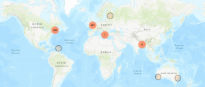
Click on red clusters to discover and recover women’s writing between 1546 and 1866. When you zoom in all the way, each bubble contains a unique edition (author, title, year, publisher, printer, etc.) and also points you to the page and line number where you can find it listed in the manuscript. Books are mapped by publication city.
There are 1,498 editions with publication places recorded in Stainforth’s library catalog. They are listed as cities in each catalog entry. We used hamstermap.com to batch translate the city addresses into geocodes and added additional metadata found in the catalog to each edition and address in an .xlsx file. We produced the map using Leaflet (https://leafletjs.com/), in javascript, with marker clusters that are labeled with numbers that count the number of markers in a cluster. This number changes as a user zooms in.
This map is a work-in-progress. It is not ideal to have it published on a URL unattached to our project website, and I am working to fix this. I have been unable to embed the map itself in WordPress. One solution is to use Maps Marker Pro and use the WordPress plugin to embed the map, and this requires reformatting our .geojson file to produce a similar clustering effect in MMP. To be continued …
Allyson Long (Dartmouth, ’17) collaborated on data editing in 2017 for a portion of the mapping data. I completed the data editing and mapmaking in Leaflet in 2018-19.


One thought on “Map of Publication Places in the Library Catalog”